
What is a riparian area?
A riparian area is the vegetated transition zone between aquatic and terrestrial ecosystems. This area is highly productive and provides natural services like:
- Water quality protection by preventing excess sediment, nutrients or heavy metals from entering water
- Regulates water and air temperature by shade from trees and shrubs,
- Protection for fish and other organisms that live in aquatic ecosystems.
- Decreased flood hazard
- Shoreline protection
- Winter precipitation retention in soil for release in summer
- Enhanced property aesthetics and value
What is the Riparian Area Protection Regulation (RAPR)?
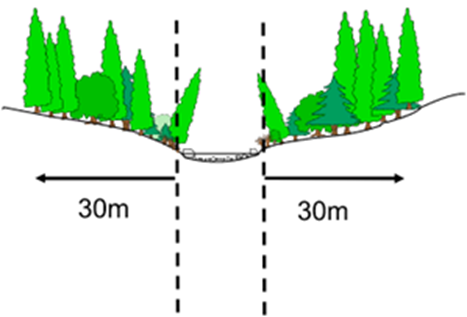
The RAPR establishes guidelines to conserve riparian areas, such as streams, lakes, wetlands or ditches, during development activities on residential, commercial or industrial property. The RAPR was amended in 2019 to improve regulatory oversight, requirements for training and qualifications by assessors, and additional detail and rigor in the application of regulations. Any project that is set to take place within 30m of a stream boundary is subject to a riparian area assessment, see figure 1 below. Note that for ravines the determination of the RAA is dependent on the size of the ravine and should be determined by a Qualified Environmental professional (QEP). The word ‘stream’ is used to identify any watercourse, e.g., lakes, ponds, rivers, streams creeks, ditches marshes and wetlands.
Examples of projects are that would require an RAPR assessment are:
- Building a structure
- Disturbing soil
- Removing or altering plants
- Servicing sewage or water systems
- Creating hard surfaces such as a deck or pavement
- Constructing a bridge or dock
What does an RAPR assessment require?
A riparian area assessment must be conducted by a qualified environmental professional (QEP) who has successfully completed the RAPR training course. The RAPR defines a QEP as a member of one of the following professional organizations:
- an agrologist (PAg),
- an applied science technologist or certified technician (AScT, CTech),
- a registered professional biologist or registered biology technologist (RPBio, RBTech),
- a professional engineer or professional engineering licensee (PEng),
- a professional forester or registered forest technologist (RPF, RFT), and
- a professional geoscientist or professional geoscience licensee (PGeo)
The QEP is responsible for identifying the streamside protection and enhancement area (SPEA) and the measures that need to be taken outside the SPEA and throughout development to protect the integrity of the SPEA. A list of QEPs in British Columbia with this training can be found here.
What do I do if my project falls under the RAPR?
If a project on your property is subject to the Riparian Area Protection Regulation you must retain the services of a QEP to conduct an assessment of the area. If your development plans don’t comply with the conditions listed in the assessment, then your plan needs to be redesigned in order to protect the integrity of the SPEA. Once these conditions are met your assessment must be filed and review by the provincial government. Then your local government may proceed with the approval process for your development if the assessment stipulations were followed.
How do I know if my project requires a RAPR assessment?
If you are uncertain if your project will fall under the RAPR, you can use this web map as a guideline. To use this map; type the address of the intended project site into the search bar, then any potential riparian areas will show up in purple on the map. The presence of riparian areas on your property may indicate the need for a RAPR assessment to occur.
Learn more
To find more information please visit the Government of British Columbia’s website.