Cowichan River
Parts of North Cowichan, the City of Duncan, Cowichan Tribes lands, and CVRD Areas D and E are located in the Cowichan River floodplain.
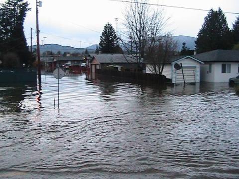
Following the 2009 flood, an Integrated Flood Management Plan was implemented and included the construction of new dikes, raising of existing dikes, installation of pump stations, and removal of log jams and gravel from key sections of the river.

Beverly Street during the 2009 flood, prior to the construction of new protective dikes.
Even with these measures, flooding can still occur. If you live on or near a floodplain, make sure you are prepared in advance and know what to do in the event of localized flooding.
Chemainus River
The Lower Chemainus River is a floodplain, which means it is prone to periodic flooding. Flooding can impact properties, infrastructure, businesses, and the environment.
Floodplain mapping work is underway (2022) by the Cowichan Valley Regional District, North Cowichan, and in partnership with Halalt First Nation and Penelakut Tribe. This mapping is critical to help manage future flooding and to develop potential options to mitigate flood damage.
North Cowichan is also expanding the distribution of supplies in the area by staging sandbags at strategic locations.
Related Content:
The Province operates the River Forecast Centre. During periods of high flood risk, the River Forecast Centre provides information on current and forecast streamflow conditions, including modeled forecast data, and flood advisories and warnings.
Learn more about being prepared for a flood, or any emergency, at PreparedBC.ca
