
North Cowichan’s watersheds include a diverse network of rivers, streams, and creeks that support healthy ecosystems and local communities.
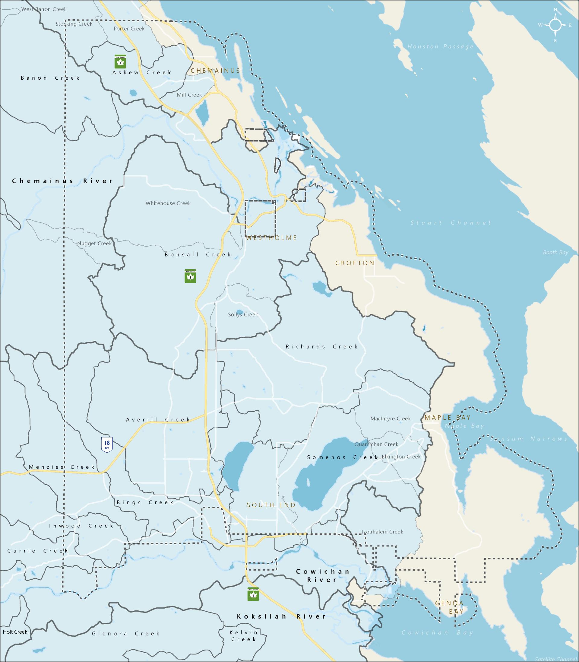
The Official Community Plan establishes goals to monitor, protect, and restore water quality, quantity, and fish habitat in all water bodies, including lakes, ponds, wetlands, marshes, rivers, streams, creeks, and ditches.
- North Cowichan’s drinking water systems rely on two separate groundwater aquifers:
- The South End system services Berley’s Corner, Bell McKinnon, Quamichan, Maple Bay, and parts of Crofton and is supplied by an aquifer on the south side of the Cowichan River.
- The portion of Crofton not supplied by the South End system is supplied via the Crofton mill and the mill’s treatment plant. The water comes from an intake pump on the Cowichan River, just upstream from the City of Duncan. A back up system is available through surface water at Crofton Lake.
- The Chemainus water system is supplied by wells near the Chemainus River, just downstream from the Trans-Canada Highway bridges. Licensing for these well is currently only for the fall, winter and spring. Since 2019, a series of short-term licences has allowed for summer operations of these wells. Conditions of these short-term licences include rigorous monitoring to ensure that summer well operations are not having a significant effect on fish habitat in the Chemainus River. North Cowichan is working with provincial regulators and Halalt First Nation to establish management goals to support long-term summer use of these wells. Halalt has maintained that well operations interfere with their management goals and historic use of the river.
- Without summer use of the wells, Chemainus would draw its water from the untreated surface water at Holyoak Lake in the Bannon Creek watershed.
Related content:
Kwa’mutsun Xasta’ (Quamichan Lake) and S-amunu Xatsa’ (Somenos Lake) watersheds
Quamichan Lake and Somenos Lake are “sibling” lakes within the Cowichan watershed. These shallow, bowl-shaped lakes formed more than 11,000 years ago when the last glaciers receded. They are both highly vulnerable to human interference including the introduction of invasive plants and fish, cyanobacteria blooms, and the impacts of adjacent agricultural activities and encroaching development.
Quamichan Lake is North Cowichan's largest lake, at just over 300 hectares with a maximum depth of almost 9 metres. Quamichan Lake is historically significant for the Cowichan People who are known to have used it for natural resources, materials, and food. The lake currently hosts a wide range of activities with rowing laneways, fishing, kayaking, bird watching, playgrounds, and the national training facility of Rowing Canada Aviron.
Work is underway on Quamichan Lake to identify mitigation approaches for cyanobacteria blooms which occur most summers.
- Read more about Quamichan Lake, its watershed, history, and water quality studies:
Somenos Lake is 100 hectares in size. The lake and adjacent marsh habitat provide valuable flood mitigation, water storage, and replenished groundwater services.
- Additional information: Somenos Marsh Wildlife Society
Somenos lake is fed by Bings Creek, Averill Creek, and Richards Creek (Crofton Lake) which flow year round. Quamichan lake on the other hand, is fed by several small creeks, which dry up in the summer, that flow from P’I’paam’ (Mount Tzouhalam) to the east rural lands to the north and west.
Quamichan and Somenos Creeks enter the lower Cowichan River just a few meters apart near Quamichan Rd.
Cowichan watershed
The Cowichan River watershed encompasses Lake Cowichan with the Koksilah watershed often added as a sub-basin. The Quamichan-Somenos watersheds join the Cowichan watershed near the estuary. The Cowichan River is designated as both a federal and provincial heritage river and it is vital to the culture and economy of the entire Cowichan region.
The river is home to five species of salmon and has been an essential part of the Quw’utsun Peoples lives since time immemorial.
The Cowichan Watershed Board is a collaborative governance partnership that facilitates management and decision making to protect the Cowichan and Koksilah watersheds.
- Learn more about the Cowichan Watershed Board
Chemainus watershed
The Chemainus River watershed covers more than 35,000 hectares, from the summits of Mount Brenton and Mount Hall to the Chemainus River estuary, where the river flows into Stuart Channel in the Salish Sea. It also encompasses the Bonsall Creek watershed area.
Holyoak Lake, Sherk Lake, and Silver Lake provide surface water storage. Holyoak Lake has served as the water supply for Chemainus, before the wells came into use.
Bonsall Creek and the Bonsall watershed are considered part of the Chemainus watershed. The Bonsall watershed is 3,600 hectares extending from the steep slopes of Big and Little Sicker mountains to the farmlands in the Westholme area.
Bonsall Creek supports the most productive rearing habitat for coho salmon in the Chemainus River system. North Cowichan works with members of the local community and Halalt First Nation to protect and restore this fish habitat and the riparian habitat adjacent to the creek.
- Read more: Bonsall Creek management plan
The lower part of the river is susceptible to flooding. The Chemainus River flood mitigation project got underway following a significant flood event in 2021. The project is led by the Halalt First Nation with support from North Cowichan, Flood Debris Management Secretariat (FDMS), Cowichan Valley Regional District (CVRD), Penelakut First Nation, B.C. Ministry of Emergency Management and Climate Readiness, Ministry of Environment and Climate Change Strategy, Ministry of Forests, and Indigenous Services Canada.
- Read more about the Chemainus River flood mitigation project
- Read more about the Halalt First Nation work on the river